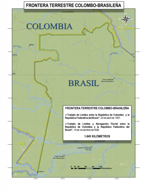

The frontier with the Federal Republic of Brazil is some 1645 km long. The arrangement of limits was complex, since the times of the Spanish Empire, the frontiers between the Crowns of Spain and Portugal in their colonial territories in the Americas were not sufficiently clear, and at the time they became independent, the new Republics inherited this situation.
In 1826, work started to solve the problem of limits, but it was only until 1907 when an agreement was reached with Venezuela with formal delimitation, and this only for the Northern section between the frontier with Venezuela (Rio Negro, opposite "Piedra del Cocuy "), and the confluence of the rivers Apaporis and Caquetá. For the final sector to the River Amazon, it took until 1928, and a settlement of delimitation arrangement was finalized with Peru, since in 1851 Brazil and Peru signed a river trade and navigation treaty, in which they recognized as limits between them, the geodetic line Tabatinga-Apaporis, in an area which Colombia claims for itself. This line was subsequently accepted as a frontier between the Republic of Colombia and the Federal Republic of Brazil.
In the 1928 treaty, the two countries recognize reciprocally and in perpetuity the right to free navigation on the Amazon, Yapurá or Caquetá, Izá or Putumayo, and all affluents and confluents.
The instruments which set a frontier between Colombia and Brazil are:
The “Treaty of Bogotá between Colombia and Brazil" signed in Bogota on 24 April 1907 by the Ministry of Foreign Affairs of Colombia, Alfredo Vasquez -Cobo, and the Resident Minister on Special Mission of Brazil, Eneas Martins.
The “Treaty of Limits and River Navigation between Colombia and Brazil", signed in Rio de Janeiro, Brazil, on 15 November 1928, between the Extraordinary Envoy and Plenipotentiary Minister of Colombia and Brazil, Laureano Garcia -Ortiz, and the Minister of State for Foreign Affairs of Brazil, Octavio Mangabeira.